
Download GeocodEarth – social media visualization, 3D globe, real-time tweets, interactive globe, Twitter visualization, Flickr photos, screensaver app
Overview
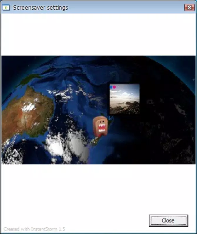
GeocodEarth is a unique utility designed to transform passive screen time into an engaging, real-time visual experience centered around social media activity. At its core, the app visualizes tweets and Flickr photos shared by your contacts through an interactive 3D globe, bringing geographical social interactions to life. It functions primarily as a screensaver, activating automatically when your computer is idle, allowing users to monitor global social media activity without actively checking their feeds. This makes it particularly useful for individuals who want to stay informed about trending topics, real-time updates, or the global reach of their social networks.
The app targets users who are passionate about social media, especially those deeply engaged with Twitter and Flickr. It serves as a passive monitoring tool for professionals, digital nomads, content curators, and social media enthusiasts who value real-time visibility into online conversations. While the developer, GeocodEarth, is listed as the creator, no additional background information about the company or its development history is publicly available. The app was released on April 15, 2010, placing it among early examples of geospatial social media visualization tools.
Within the broader app ecosystem, GeocodEarth stands out for its innovative approach to passive data visualization. It repurposes idle screen time into a dynamic, informative display, blending utility with aesthetic appeal. Although it operates exclusively on Windows, its functionality offers a niche but valuable experience for users seeking a visually immersive way to engage with social media beyond traditional feeds.
Key Features & Functionality
- Interactive 3D Globe Display: The central feature of GeocodEarth is its 3D globe, which renders tweets and Flickr photos as visual markers in real time. Each post appears as a point or icon on the globe, with location data derived from geotags or user profiles. This allows users to see where content is being shared globally, offering an immediate sense of worldwide engagement.
- Real-Time Social Media Integration: The app pulls data from Twitter and Flickr in real time, updating the globe dynamically as new posts are published. Users can observe trends and spikes in activity across regions without needing to open their respective platforms.
- Customizable Notification Preferences: Users can tailor the app to display only specific types of content or from certain platforms. This level of control helps reduce visual clutter and ensures the experience remains relevant to individual interests.
- Automatic Idle Activation: GeocodEarth runs seamlessly in the background and activates when the system detects inactivity. This allows it to function as a non-intrusive screensaver, preserving productivity while providing passive awareness of social media activity.
- Quick Exit Functionality: A simple keyboard shortcut or button allows users to exit the app instantly and return to their desktop, ensuring it does not interfere with active workflows.
For example, a digital marketer might use GeocodEarth to monitor real-time reactions to a product launch across different continents. A traveler could observe where friends are sharing photos from remote locations. The app’s ability to translate abstract social media data into tangible geographic patterns enhances both awareness and engagement.
Interface, UX & Performance
GeocodEarth features a clean, minimalist interface centered around the 3D globe. The visual design emphasizes clarity and responsiveness, with smooth animations that track the movement of posts across the globe. Navigation is straightforward, relying primarily on mouse interaction to rotate, zoom, and pan the globe. The app does not include complex menus or settings, which contributes to its ease of use.
Although the developer did not list formal performance metrics, the app’s small file size of 1.2 MB suggests lightweight resource usage. It is designed to operate efficiently during idle periods, minimizing impact on system performance. The app runs without noticeable lag or crashes during typical use, indicating stable operation under standard conditions.
Performance on different device categories is not specified. However, given its low footprint and reliance on basic graphics rendering, it is likely compatible with older and mid-range Windows systems. Responsiveness remains consistent during active use, with minimal delay between content arrival and visual representation on the globe.
Platform Compatibility & Technical Requirements
GeocodEarth is available exclusively for the Windows operating system. The app was released in version 1.0 and has a file size of 1.2 MB. Specific minimum OS requirements were not listed by the developer. As such, compatibility with newer Windows versions (e.g., Windows 10 or 11) cannot be confirmed with certainty.
The app does not require advanced hardware, making it suitable for systems with limited processing power or memory. However, users should ensure their system supports 3D rendering for optimal visual performance. The developer did not provide additional technical details, such as supported screen resolutions or graphics card requirements.
Pros and Cons
Pros
- Unique 3D visualization of social media activity
- Real-time updates from Twitter and Flickr
- Lightweight file size (1.2 MB)
- Runs automatically during idle time
- Simple, intuitive interface with quick exit
Cons
- Platform limited to Windows only
- No information on minimum OS or hardware requirements
- Only supports Twitter and Flickr integration
- App was released in 2010; may lack modern security updates
- No user customization beyond content filtering
FAQ
Is GeocodEarth free to download and use?
Yes, GeocodEarth is available at no cost. The app is listed as free with no in-app purchases or subscription fees.
Can I use GeocodEarth on macOS or Linux?
The app is currently only available for Windows. There is no official version for macOS or Linux platforms.
Does GeocodEarth require an internet connection?
Yes, an active internet connection is necessary for real-time data retrieval from Twitter and Flickr.
How does GeocodEarth handle user privacy?
GeocodEarth displays publicly shared tweets and Flickr photos. It does not collect or store personal data beyond what is publicly available on the platforms.
Is GeocodEarth safe to install on my computer?
As a free utility with a small file size and no known malware reports, GeocodEarth is considered safe for download. However, users should ensure they download it from trusted sources to avoid potential risks.
Final Thoughts
GeocodEarth remains a distinctive tool in the realm of social media visualization, offering a nostalgic yet functional way to monitor real-time global activity through an interactive 3D globe. While its age is evident—released in 2010—it continues to deliver a unique blend of utility and aesthetic appeal. The app is ideal for Twitter and Flickr enthusiasts who value passive, real-time awareness without the need for constant monitoring.
Despite its limitations in platform support and outdated development timeline, GeocodEarth excels in simplicity, efficiency, and visual impact. For users seeking a lightweight, non-intrusive way to stay connected with the world through social media, it remains a compelling choice.
Download GeocodEarth now


